Topographical Surveys | Manchester
Topographical Survey Manchester
Accurate land survey data for planning applications and development projects across Manchester and Greater Manchester, delivered fast.
Get a QuoteAccurate land survey data for planning applications and development projects across Manchester and Greater Manchester, delivered fast.
Get a QuoteManchester sits at the confluence of the Rivers Irwell, Medlock and Mersey, with a complex urban topography shaped by decades of industrial development and regeneration. For planning applications across Greater Manchester, topographical surveys are a standard pre-application requirement and are expected by Manchester City Council before any application involving new development or significant external works is validated. 105 Surveys delivers topographical surveys across Manchester, Salford, Trafford, Stockport, Tameside, Oldham, Bury, Rochdale and the wider Greater Manchester area, with data and drawings delivered fast to keep your application and development programme on track.
Every topographical survey we deliver in Manchester meets the data standards expected by Manchester City Council and is formatted for direct use in planning submissions and design work.
Survey data delivered quickly after site visit, keeping your Manchester planning application or development programme on schedule.
We cover Manchester and all of Greater Manchester, with no call-out restrictions across the North West. One call gets your survey booked.
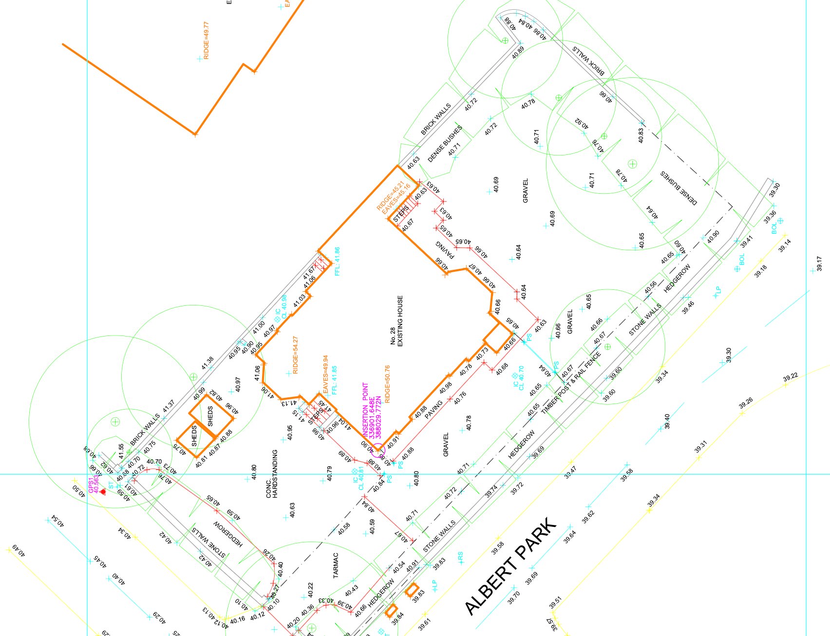
A topographical survey is a detailed measurement of the ground surface — recording existing levels, features, boundaries, services, vegetation and all above-ground structures on and around a site. Planning authorities across Greater Manchester require this data to understand the existing site conditions before considering any new development proposal.
Manchester City Council, Salford City Council and Trafford Council all expect topographical survey data to accompany planning applications for new development and external works schemes. We ensure every topographical survey delivered in Manchester is accurate, correctly formatted and ready to submit with your planning application without amendment.
Topographical survey data is the base on which every new-build and site development design in Manchester is built. Without accurate levels and feature data, your design is built on assumptions that will surface as problems during planning or on site.
Manchester City Council, Salford City Council and Trafford Council all expect topographical survey data to accompany planning applications for new development and external works schemes. We work directly with planning consultants across Greater Manchester to ensure survey data is submitted in the right format, to the right specification, first time.
For residential development sites, commercial land acquisitions, drainage assessments, highway works and pre-application planning due diligence across Greater Manchester, accurate topographical survey data at the front end reduces risk, supports accurate design and prevents costly redesign when issues emerge later in the programme.
Greater Manchester has seen sustained development activity across its inner city and suburban boroughs for over a decade. The types of site requiring topographical surveys in Manchester range from urban infill plots in Ancoats and New Islington to suburban garden and backland development in Didsbury, Chorlton and Stockport. Each site type presents different survey challenges: urban plots often have complex boundary conditions, party wall situations and utility apparatus that must all be recorded; suburban sites require accurate level data across larger areas with vegetation and highway interfaces.
Manchester City Council's Local Validation List specifies that topographical surveys must accompany planning applications for new development. The survey must show existing levels, drainage features, tree positions, boundaries, structures and highway details at a scale appropriate to the site. For sites within flood risk zones — particularly those near the Rivers Irwell, Medlock or Mersey — a topographical survey is essential for the Flood Risk Assessment that accompanies the planning application.
Salford City Council and Trafford Council apply similar validation requirements for their areas. Salford's MediaCityUK and Salford Quays development zone has produced a steady stream of planning applications requiring topographical surveys over the past several years, typically for commercial development, mixed-use schemes and infrastructure works. We have experience delivering to the level of detail expected for planning submissions in both councils.
We cover all of Greater Manchester for topographical surveys — Manchester city centre, Salford, Trafford, Stockport, Tameside, Oldham, Bury and Rochdale — and can mobilise quickly for urgent pre-application surveys. Call 0151 272 3479 to discuss your site and get a fixed-price quote within 24 hours.
We cover Manchester and surrounding areas including Salford, Stockport, Trafford, Didsbury and Chorlton, and more across Greater Manchester. We also deliver topographical surveys across the wider North West. Call 0151 272 3479 or email info@105surveys.com to see how we can help with your project.